
See here for further stories of County Carlow
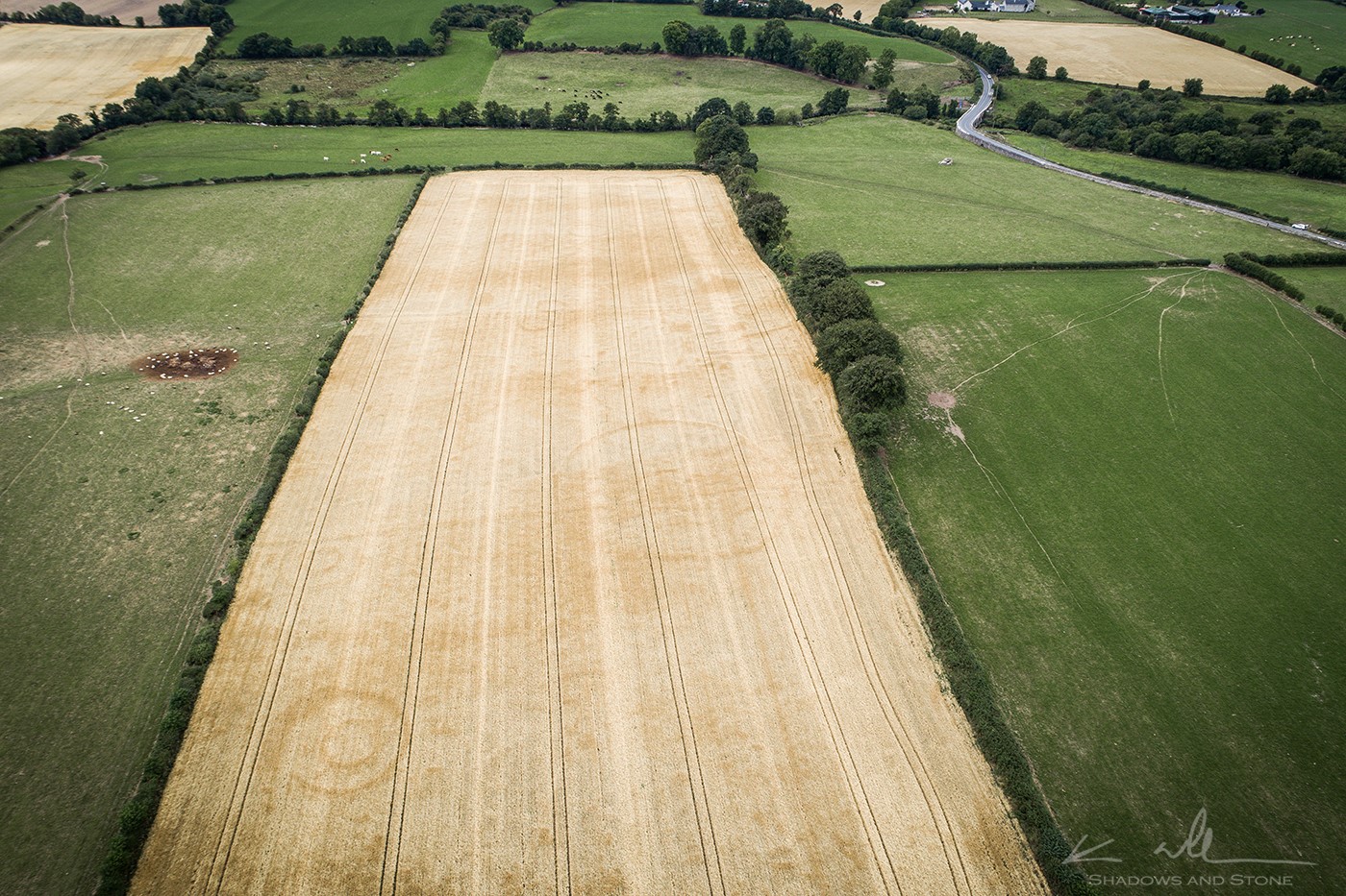
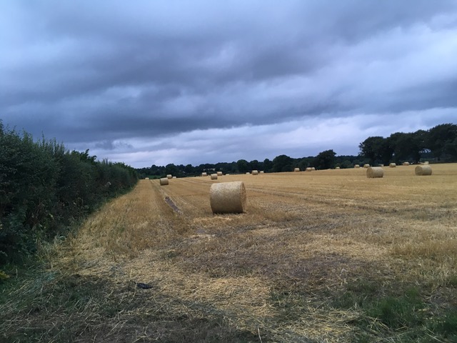
Photographed in August 2018 by Ken Williams of Shadows and Stone, this drone photograph of Ballykilduff shows the outline of several barrows and ring-ditches, as well as a large circular enclosure, in the Long Field behind the Haroldstown Dolmen in County Carlow. The road on the right is the R727 from Hackestown to Tobinstown, the bendy bit is Acaun Bridge and the grey lump in the field by the bridge is the dolmen. This incredible photo, made possible by the long drought, is the first indication of any such complex in this area.
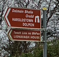
Located on the River Dereen in County Carlow, the townland of Haroldstown measures 141.57 hectares (349.84 acres) and includes the beautiful portal tomb, known as the Haroldstown Dolmen, while neighbouring Ballykilduff appears to have been home to a Bronze Age settlement that was first charted by a drone in 2018. Closely linked to the nearby monastery at Acaun, its past owners include two former Lord Chancellors of Ireland and an eccentric newspaper man. It was also the scene of an appalling eviction of 173 tenants in the 1830s, including numerous widows, of which further details can be found below.
Along its western side, Haroldstown is bordered by the tiny monastic townland of Acaun, as well as Lisnavagh (sometimes Lisnevagh) and Tobinstown. To the south is Ballykilduff Lower, to the east lie Ballykilduff Upper and Raheen, while Williamstown runs to the north.
The River Dereen

Downstream on the River Derreen at Acaun. Photo: Turtle Bunbury (2021)
The River Dereen, which flows just east of Lisnavagh, appears to rise to the east of Rathdangan, possibly on Torboy Mountain or Slieve Boy Mountain but I’m willing to stand corrected. It then runs south past Knocknagree, Rathduffbeg and Kilcarney, under Rathduffmore Bridge, past Ballybrack and Rathnafushoge to join the Scotland Brook (which rises in a bog behind my friend Martin Kelly’s family home in Knockananna).
Westwards it now courses to just above Hacketstown, slaloming past Ballykillane to Saulsford Bridge. “Saul’s Ford” was named for a Protestant farmer who owned the farm here. It was once an especially dangerous ford on the Hacketstown road, requiring the bridge which was built early in the 19th century. From here the river sweeps north again to join the Douglas River (from Kiltegan and Tombeagh) above Nashe’s Quarter.
The river then continues west past the monastery at Acaun and the Harodlstown Dolmen, converging with the Slaney just upstream of Aghade Bridge in Ardattin. It is a specially conserved channel because of the salmon, trout and pearl mussel found within.
If I have erred with my charting of its course, please correct me. I have sometimes been tempted to bring my daughters on a kayak down the Dereen from Acaun but a friend who knows the river much better than I advises that it is not for a novice group as there are a lot of low trees and obstacles, making it quite dangerous. The river comes up fast during rainy weather and looks especially spectacular in full flood. An otter was spotted on its banks in 2018.
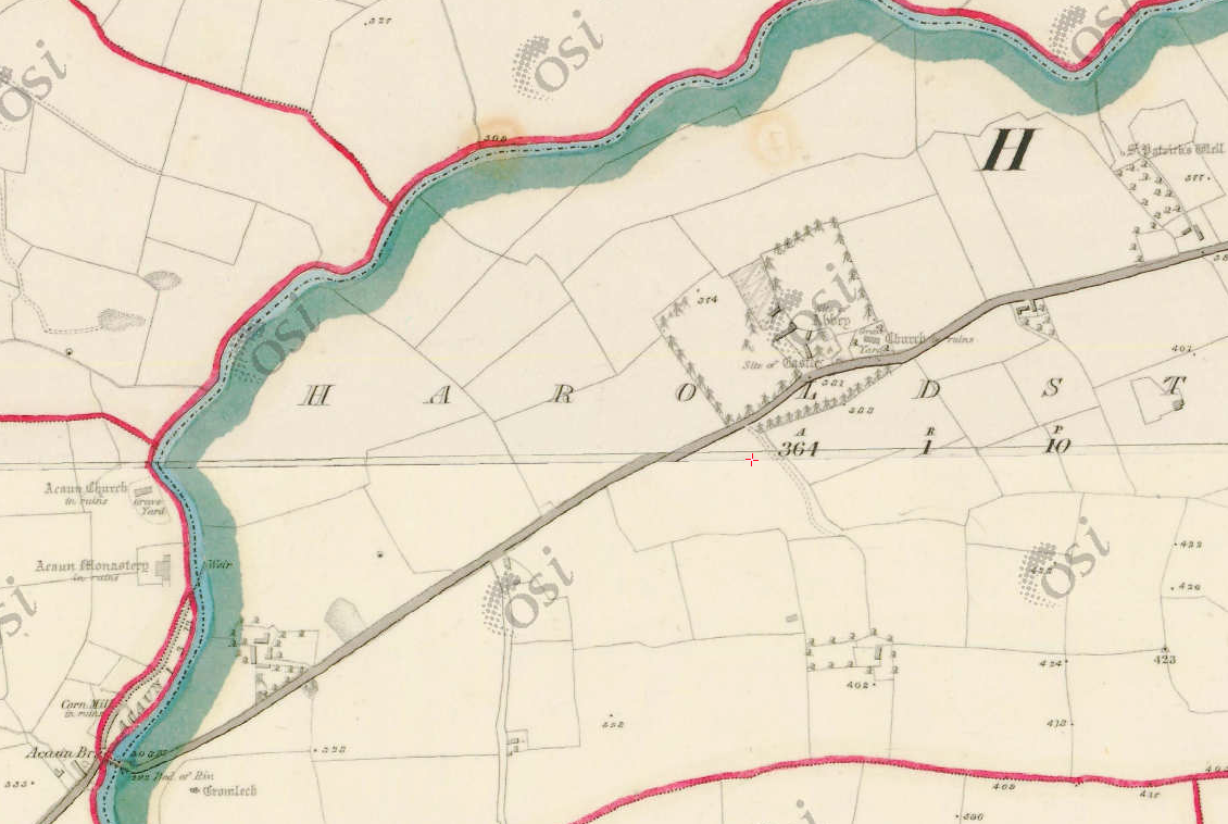
The Ordnance Survey Map of Ireland shows the Haroldstown Dolmen (or cromlech), as well as Acaun Bridge, Mill, Monastery and Church. It also indicates a ruined church and the site of both a castle and an abbey just to the east in Haroldstown and, beyond that, a well devoted to St Patrick. Was this Williamstown Castle where the Cogan family lived? Was the well the one into which treasure was allegedly thrown to save it from Cromwell!?
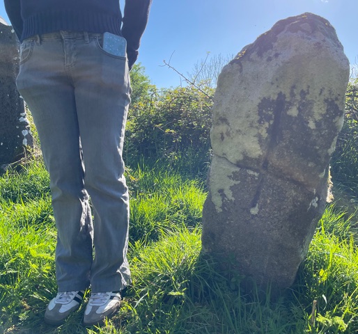
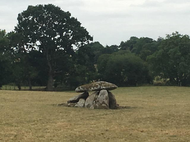
Haroldstown Dolmen

Cattle at ease by the Haroldstown Dolmen
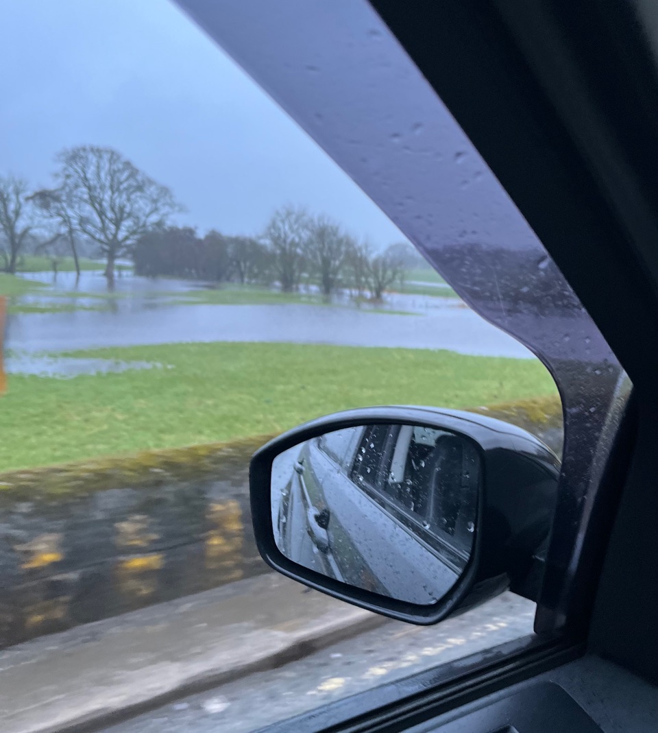
Flooding by Haroldstown Dolmen, 2026
During the course of its journey, the Dereen flows beneath Acaun Bridge, near to the Haroldstown Dolmen. Standing on a ridge overlooking the river, the dolmen comprises a huge flat slab on top of half a dozen uprights stones. This is the denuded remains of what was once a very large portal tomb; one of many in the Slaney-Three Sisters area.
According to the OPW’s Archaeological Inventory of Carlow, such dolmens were constructed between 3300 and 2900 BC, probably by the farming community who lived here, and their chambers were filled with the cremated ashes of all those who lived in the area. (The pyramids were built between 2630 and 1814 BC while Stonehenge was built, in different stages, between 3100 and 1500 BC.)
I’m biased because I’ve spent most of my life living a stone’s throw from this Stone Age beauty but it really is a picture perfect megalithic gem. When my daughters were toddlers, they were convinced it was built by Asterix and Obelix. I think that when I finish up in this life, I’d like some of my ashes to be scattered here. If nothing else, it’ll utterly confound anyone doing a DNA reading of those interred here long ago.

Watercolour of the ‘Cromlech at Haroldstown’ (County Carlow) by Charles Vallancey. It is hard to imagine that it ever actually looked like this, and I believe Vallancey had a fine imagination.
In 1837, Samuel Lewis offered this description in his Topographical Dictionary of Ireland”
“On the townland of Tobinstown there is a large cromlech; at the west end are two pillar stones, eight feet high; the table stone is twenty-three feet long, and at the west end eight feet broad, but at the other, which rests on small stones elevated about a foot from the ground, it is only six. The thickness at the upper end is four feet, at the lower two; the under surface is plain and even, but the upper is convex. Along the sides are several upright stones, from three to six feet, rendering the space underneath an enclosed room, entered between the two tall uprights. From this entrance is a sort of avenue, forty yards long, formed by small irregular artificial hillocks: the whole is in a low plain field, near a rivulet, on the road from Tullow to Hacketstown.”
Does this avenue still exist!? Was the road running past the dolmen straighter in times past? Edwin Burgess espied a line of ash trees on the bank that he feels mark the border of an earlier road.

Whatever about Vallacney’s exaggeration, that is nothing compared to this illustration purporting to be the ‘cromleh’ [sic] at Tobinstown. It appeared in a work in 1829 by the Yorkshire-born archaeologist Godfrey Higgins (1772-1833) with the catchy title, “The Celtic Druids, Or, An Attempt to Shew that the Druids Were the Priests of Oriental Colonies who Emigrated from India, and Were the Introducers of the First Or Cadmean System of Letters, and the Builders of Stonehenge, of Carnac, and of Other Cyclopean Works in Asia and Europe.” Higgins was reputedly a “Chosen Chief” of the Order of Druids, founded by John Toland in 1717, and a member of An Uileach Druidh Braithreaches (The Druid Order). But imagine if it did look like this!
In the early 20th century, Lord Walter FitzGerald noted that this was ‘a very good specimen of a “Giant’s Grave” or “Druid’s Altar.”‘ [1]
Ballykilduff Barrow Graves
On 4 August 2018, photographer Ken Williams (Shadows and Stone) and his son discovered a Bronze or Iron Age barrow cemetery in what I have opted to call the Long Field at Ballykilduff, beside the Haroldstown Dolmen. They managed to photograph the sites just hours before the field was harvested. According to Ken:
‘The complex consists of several barrows and ring-ditches as well as a large circular enclosure, which seems to have an inner barrow from certain angles. There is no previous record of any monuments in this particular area. It is just two fields [I think one – ed.] away from the wonderful Neolithic portal tomb of Haroldstown. Two of the barrows have double concentric ring-ditches. There are at least three and maybe four single ring-ditches and other unidentified features. The dry conditions over the previous few weeks have created perfect conditions for previously unseen crop marks to appear. They are caused by deeper or shallower soil having more or less soil depth, nutrients and water. Generally, the crops growing in deeper soil resulting from features cut into the ground show a darker colour and those on shallower soils where raised banks and other built-features occurred show as lighter crops.’
Having been kindly advised where it was by Edwin Burgess, I swung in for a whistle-stop visit to the freshly cut “Long Field” the following day. It turns out that it is actually just beside the “dolmen” field and the dolmen was thus, one imagines, the burial site for a community who lived in what my wife and I were soon hallucinating to be a full-blown village of circular double-ring structures, visible in Ken’s aerial photograph of this fertile, funerary landscape, both in the Long Field and in the ones adjacent to it.
There are certainly more circles in the lower left-hand corner of the field just north of the Long Field, closer to the R727. As my pal Jamie Cahalane said, ‘It must have been a pre-historic housing estate -Boneville, Rockville. &c.’
Ballykilduff is a separate townland to Tobinstown.
The rings may be enclosed farmsteads, or ringforts, which are the most common type of filed monument in Ireland. A ditch running along the field has been identified as a townland boundary by James Grogan (separating Ballykilduff from Haroldstown presumably?). James also observed that two lines crossing the field in Ken’s photos were also ditch lines. Old maps of the area also indicate the remnants of two field boundaries running through the Long Field. Ken says the wheat fields on the other side of the river didn’t show any obvious markings. To find the Long Field, I turned right off the R727 just after the old “dump” and it was the first wheat field on the right. What makes it particularly pleasing to me is that when I returned home to Oldfort and looked back in that direction from our front steps, I could see series of golden flashes through the hedges and trees – and, unless I am mistaken, those golden flashes are from very same Long Field! The field belongs to Peter Murphy, as does the field with the dolmen in it. [2]
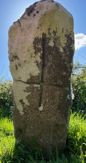
 Haroldstown Cross Stone
Hats off to All About Carlow for its April 2025 post on Facebook here alerting followers to the existence of an early Christian cross-inscribed pillar stone (CW004-038003) in the Haroldstown graveyard. It is located immediately as one enters the graveyard, alongside three tall gravestones, just south east of the church. (See further details on the graveyard below.)
There is portion of a moulded granite jamb in the graveyard. Likely dating from the 7th to 10th century AD, this is one of the oldest tangible Christian relics in the county.
The graveyard is accessed by a kissing gate on the main road, almost directly opposite Rivendell, a private Nua Healthcare facility, at R93 C527.
Haroldstown Graveyard
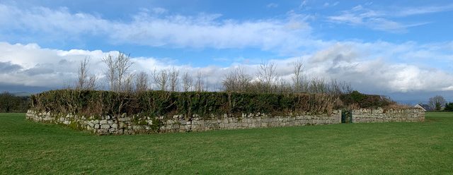
Haroldstown Cemetery is the resting place of the Scott and Abbey families, among others. There is a suggestion that there was once a castle just west of the cemetery. That said, the OS letters of 1839 refer to ‘no definite traces of the castle … standing’.
The cemetery is on the left-hand side of the R727 heading from Tobinstown Cross towards Hacketstown. Pass the recycling centre on the left and you’ll see it about 200 yards before the junction to Clonmore, directly opposite the Rivendell care facility at R93 C527. The graveyard is accessed by a charming kissing gate on the main road, with a second kissing gate off the main road. The kissing gates were installed circa 2000 after pressure was exerted on Carlow County Council by those with family buried here.
The graveyard is surrounded by an old stone wall and contains many 18th- and 19th-century headstones, with some grave markers dating back as early as 1711.
The walled enclosure is apparently in about the same location as a ruined castle. Was this graveyard also once been attached to a now vanished church?
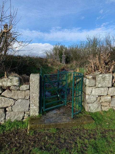
The entrance to the Haroldstown Cemetery is a charming kissing gate.
Emma McGrath has transcribed the names of those in Haroldstown Cemetery as an appendix in a book called ‘One Hundred Years Too Soon – Hacketstown & 1798’ by the late Robert Duffy (Hacketstown Area Community Council, 1998). The family names of those interred within are Abbey, Byrne, Curran, Doyle, Hickey, Kearney, Kissanne, Murphy, Neil and Scott. Bridget Hemming stated (here) that her grandfather is in that grave yard. Regarding the Abbeys, I note Catherine Abbey (d. 1958), Michael Abbey (d. 1924), Nan Morrissey (d. 1944), Patrick Abbey (d. 1972)
Hats off to Anthony Heaney from All About Carlow who, working with Peter Murphy, launched a campaign to protect Haroldstown Graveyard and its collapsing walls. This followed his April 2025 post on Facebook here, alerting followers to the existence of an early Christian cross-inscribed pillar stone (CW004-038003) in the Haroldstown graveyard. It is located immediately as one enters the graveyard, alongside three tall gravestones, just south east of the church.
There is portion of a moulded granite jamb in the graveyard. Likely dating from the 7th to 10th century AD, this is one of the oldest tangible Christian relics in the county.
In his 2025 post, Anthony Heaney observed that caretaker Michael Kelly had submitted a report in 1924 noting that Patrick Carroll of Haroldstown had taken it upon himself to cut young trees growing on the graveyard’s fencing. While likely done with good intentions, the action prompted the local board to seek an official explanation—perhaps a sign of early tensions between community initiative and bureaucratic oversight.
In 1935, the Nationalist and Leinster Times ran the following:
Christian cross-inscribed pillar stone at Haroldstown.
‘Mr. T. F. Elmes reported that the walls of the Haroldstown graveyard were in danger of collapsing due to tree shrubs growing from the walls. The cost of cutting the trees and preventing their regrowth would be £5. It was ordered that the trees be cut.’
Jake Keogh was caretaker there in the 1970s.
The graves were greatly bramble-strewn when I visited in February 2022, with three graves to the Scott family towering high, and a fourth, nearby, to Catherine Abbey, her husband Michael and their daughter Nan Morrissey. (They’re all related to Betty Scott.)
It was no better, and a little worse, when Bay and I popped back in early 2025. Peter Curran highlighted this on KCLR in June 2025, just after the news report, here.
On the back of Peter’s campaign, and an All-About Carlow Facebook post, Councillor Brian O’Donoghue brilliantly arranged for the graveyard to be strimmed and cleared in July 2025. Peter adds:
‘When the undergrowth was cleared, the old path surrounding the inside of the boundary wall was there for all to see. The foundations of the old church ruin was visible also.’
In September 2025, Perter consulted the ombudsman in Dublin about the up keep of the graveyard.
The graveyard enjoys a glorious view of Keadeen Mountain.

New stone found by Peter Murphy at Haroldstown, 2025
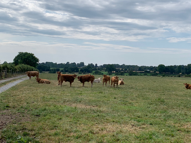
Cattle in a field at Ballykilduff close to where the barrow graves lie.
The Long Field at Ballykilduff where the barrow graves lie.
Harold or Herald?
I am unsure who Haroldstown is named for, if anyone. The Ordnance Survey Parish Namebooks, usually written by John O’Donovan, claim make a claim in 1839 that it was connected to a family of Danish origin by name of Harold, and the name becomes ‘Bhaile Eireoil’, meaning the townland or homestead of Harold.
However, the earliest record I have found is from 1697, and refers to it as ‘Heraldstowne.’
As a battle of Hastings enthusiast, I’ve always enjoyed the idea that Haroldstown lay right directly south of the townland of Williamstown.
There is also a holy well at Haroldstown, but as Jim Shannon observed in ‘Hacketstown – A History’ (2022), it is ‘not frequented nowadays.’
The Union of Hacketstown, 1693
In 1693 the vicarage of Haroldstown was episcopally united with Hacketstown in the Diocese of Leighlin.
In 1810, it was noted that there was a glebe house in Haroldstown, of 6 acres, ‘contiguous to the site of the old church, and three miles distant from the [two] glebes in Hacketstown: The Rev Daniel Mac Neille, the Incumbent (in 1806), who has cure of souls is non-resident by reason of incurable infirmity; The duties are discharged by The Rev Mr Dooley, his Resident Curate, at a Salary of £90 per annum.’ [3]
The Lord Chancellor and the Jacobite, 1702
 As mentioned above, the earliest record I have found is from 1697 and refers to ‘Heraldstone’ as the property of a Catholic Jacobite by name of John Baggot of Crosclogh, County Carlow. John’s son Mark Baggot served as sheriff of County Carlow in 1689 under the Jacobite regime. John was subsequently attainted for his support of James II during the War of the Two Kings. William Conolly, the future speaker, seems to have been involved in the attempt to wrestle Mark Baggot’s Carlow landholdings from him on behalf of the Duke of Ormonde. (See here.)
in 1702, a 250-acre parcel of land at ‘Heraldstown’ was part of the Baggot estate of over 3,000 acres (including 750 acres at ‘Portrusheen, with Toobinstown [ie: Tobinstown] and part of Buolymore’) granted to the Right Honourable Philip Savage (1644–1717), Chancellor of the Exchequer on 24 March 1702 ‘in consideration of £394 and ten shillings.’ Savage’s grant was ‘inrolled’ on 8 April 1703 with this accompanying note:
‘The estate of John Baggott, Esq., attainted; which having been granted 26th Feb., 1697, to Joost, Earl of Albemarle, were by him, by deeds of lease and release, dated 27th and 28th February, 1698, for the sum of three hundred pounds conveyed to Charles Balwin, of Dublin, Esq., in trust for Mark Baggott, Esq., to whom, by deeds of lease and release, dated 8th and 9th March, 1698, he conveyed the same in execution of the said trusts; and the said Baggott, by indenture dated 22nd March, 1702, assigned and made over his interest and right of purchasing the premises from the trustees, for three hundred and five pounds ten shillings to said Ph. Savage.’ [5]
Born in 1644, Savage was the only son of Valentine Savage and his wife Anne (née Haughton), both of Dublin. An attorney by profession and a Tory in politics, he was closely allied to his brother-in-law Richard Ryves (1643–93), the future Baron of the Exchequer court (1692–3) who would buy Rathsallagh House near Dunlavin. He became Lord Chancellor in 1695 and held the office until his death in 1717; Sir Charles Meredith, the previous incumbent, was probably another brother-in-law and husband to Savage’s sister, Judith. Savage was also Vice-admiral of Leinster from 1708 to 1710 and again from 1711 until the Hanoverian Succession in 1714. His daughter Anne Savage married Sir Arthur Acheson, 5th Bt. [6]
Ryan of Haroldstown
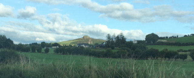
Eagle Hill from Haroldstown
John Ryan, the early 19th century Carlow historian, and sometime editor of the Carlow Standard, claimed descent from a branch of the Ryan family who lived at Haroldstown. Anthony Ryan who was, in 1700, ‘allowed, by the court of claims, an estate for lives of Haroldstown, barony of Rathvilly, containing 250 acres.’ This, wrote James Ryan, was ‘the best proof of his loyalty to King William’s government.’ Two members of the Ryan family were apparently killed at the Boyne, fighting under the banners of William III.
David Ryan, Esq, of Haroldstown, married Miss Pole from the city of Dublin but their only child died young. His second wife was Miss Roche, a sister of Nicholas Roche of Coolmanagh, with whom he had John, David and Sarah. Mrs Roche survived him and was subsequently married to the Rev Richard Brough, curate of the parish of Rathvilly, a kinsman of the Broughs of the Carlow militia.
In about 1760, John Ryan, the eldest son, settled at Broghillstown, half a mile from Rathvilly; he possessed an estate of lives, renewable forever, of the lands of Tombay (aka Tombeagh), near the confluence of the rivers Dereen and Douglas, and other lands, totalling 800 acres. About two years later, he sold these lands to a man named Pilsworth for £1500. Pilsworth’s daughter appears to have married (as his first wife) John’s brother, David Ryan of Baron Hill (who sought £238 compensation after the 1798 Rebellion). After Pilsworth’s death, the lands reverted to the Howard family, who held the fee. In 1850, Sir Ralph Howard, an absentee landowner based in London, held a 202-hectare estate which surrounded Hacketstown, in the parishes of Haroldstown and Rathvilly. He was related to the Lecky family of Ballykealy.
John Ryan’s wife was Mary Mulligan of Rathvilly. The Ryans intermarried with the Shepard family of Paulville and Tankardstown; the Shepards also held Knocknegan circa 1800-1820. [7]
Thomas Trotter’s Lands?
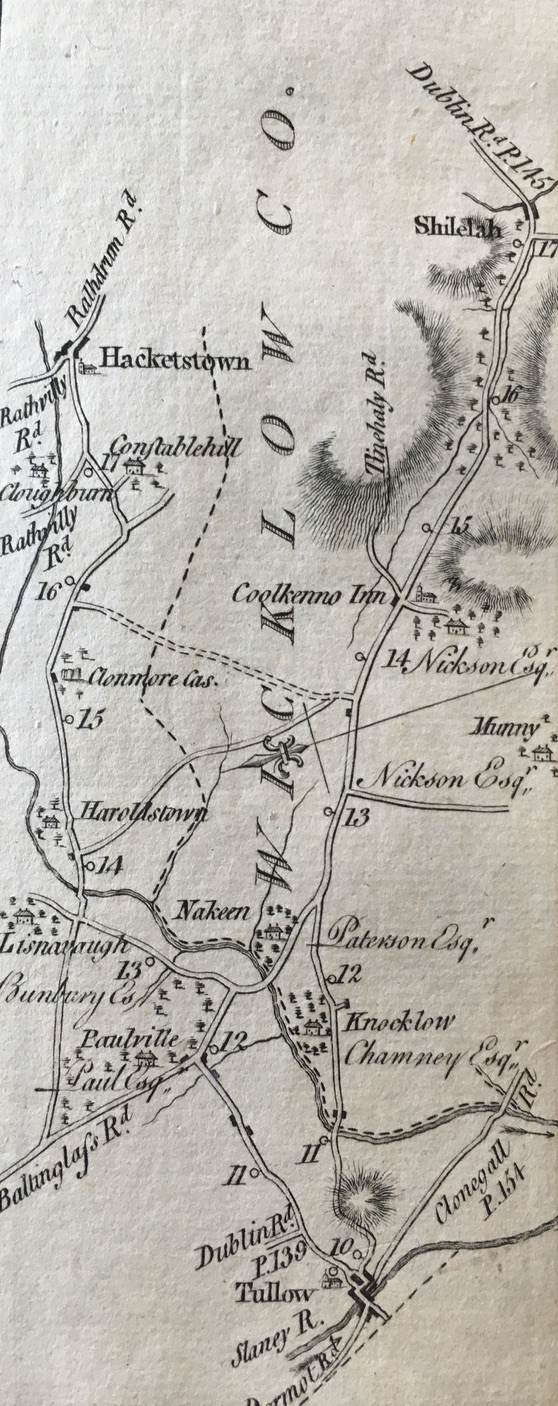
Extract from Taylor & Skinner’s map showing Haroldstown and Lisnavagh. Nakeen is assumed to have been Acaun but it seems to be in the wrong place, being located on the far side of Tobinstown Cross from Lisnavagh, heading towards Rathwood, on the left. For more, see Acaun.
A sales notice from 1806 referred to ‘the town and lands of Haroldstown, situate in the county of Carlow’ as being among the former estates of Thomas Trotter, late of Duleek House, County Meath. These were to be sold on 14 April 1806 in the Chancery Chamber in Dublin by Thomas Walker on behalf, I think, of the widow, Elizabeth Bradith. [4] I think Trotter was a supporter of the Patriot Party in the Irish Parliament, and a friend of Henry Grattan and Lord Charlemont.
Abraham Brewster & the Haroldstown Evictions, 1831-1835
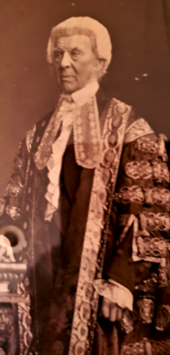
Abraham Brewster, Lord Chancellor of Ireland, who owned Haroldstown at the time of the evictions. Photo: Thomas Cranfield, 1861.
In 1831, Abraham Brewster (1796-1874), an upcoming barrister, succeeded to the townland of Haroldstown on the death of his relative, Abraham Jones. [8]
Brewster was apparently born in Ballynultagh (Ballinulta), near Tullow, in 1796. After a early education at Kilkenny College, he studied law in Trinity College Dublin. In 1819, he married Mary Ann Grey by which he later inherited Upton House and estate in County Carlow.
Following his inheritance of Haroldstown in 1831, Brewster immediately had half the townland cleared of the 17 families, all Catholic, living there, including nine widows. It was a devastating sign of what was to come. On 21 October 1841 the Dublin Monitor carried an article stating that ‘all but two of the objected widows have died’. The article ran under the heading “Is Brewster an Exterminator?”
In 1835, Brewster took advantage of the death of Luke Harney, lessee of the other half of the townland, to clear it of another 29 families, constituting 93 people. The total number of persons cleared from Haroldstown by these two appalling sweeps was 173.
The Carlow Sentinel supported the clearances with the following commentaries:
‘RATHVILLY PARISH- THE REV. JOHN GAHAN P. P. AND AGITATOR.
Haroldstown — A Townland out of which Twenty-nine families were lately ejected, for non-payment of rent due for years, paid by the tenantry into the pockets of agitators for electioneering purposes — this is a loss to the Reverend demagogue of Fifty Pounds annually.’ [9]
‘On Tuesday last the sub-sheriff, H. Butler, Esq. of this county, proceeded to the lands of Haroldstown to obtain possession of several farms, for the non-payment of rent due to Counsellor Brewster. In almost every case the sheriff, who was accompanied by a strong police force, was obliged to break into the houses, where the occupiers were prepared with pitchforks to make resistance; fortunately, however, the parties were ejected without having recourse to such coercive measures as are necessary to enforce a legal right. Six of the farmers so ejected were electors, and although three years in arrears to their excellent and indulgent landlord, they set him at open defiance at the late election, and polled in his presence, telling him and those around them that Mr. Raphael would pay up their arrears to the land- lord ! and this we are credibly informed the priest who drove them to the hustings promised should be done by their Catholic representative, Mr. Raphael. Here are the bitter fruits of recklessly opposing law and authority, and ungratefully repaying their landlords for their paternal kindness and indulgence for years.’ [10]
The Dublin Evening Packet and Correspondent offered a different version, stating that Brewster had paid the tenants to leave as the land was “worked out.” However, instead of vacating, the tenants had moved to another portion of the town land in contravention of the agreement and Brewster was apparently “forced” to take legal action to evict them.
Details of Abraham Brewster’s funeral from the Irish Times, July 1874, courtesy of Aoife McAdam.
On Monday 18 October 1841, Daniel O’Connell addressed his fellow members of the Loyal National Repeal Association in a meeting at the Great Rooms of Dublin’s Corn Exchange in which he railed against the appointment of barrister Brewster as ‘secret adviser at the Castle,’ stating:
‘Now, Mr. Brewster, I admit, is a man thoroughly competent, by his legal knowledge, and his station in his profession, to be the legal advisor at the Castle : there is no doubt of that. Between him and me there is no enmity, and I am free of all personal animosity towards him. He never offended me; I have had no hostile intercourse with him of any kind. I deem him a consistent man, and according to his lights a conscientious man ; but this I know, that a more truculent enemy of the Catholics and of Catholicity does not live – a conscientious enemy if you please, but not the less determined on that account: on the contrary, the most formidable enemy of religious liberty is the conscientious bigot who thinks he is doing right when he inflicts injury, and injures others in the name of the God of charity (hear). I do believe that there is not so avowed an enemy of the rights of the Catholic people of Ireland at the bar as Mr Brewster.’ [11]
As to the evicted tenants, O’Connell observed:
‘Most of the poor creatures have remained nearly houseless to the present day—some sheltering themselves in temporary huts on the road side —some in the ruins of an old mill, where they have passed the winter in the deepest misery.’
Could this have been the ruined mill at Acaun?
O’Connell then told how the population of Carlow had bucked the general trend by decreasing between 1831 and 1841, on account of land clearances, before homing in on the townland of Haroldstown where the Rev. Mr Denis Lalor (sometimes Lawlor), then parish priest of Hacketstown and Clonmore, had sent a letter about depopulation to Mr Vigors. [12] The Rev. Lalor, who went on to become Vicar-General of the diocese and parish priest of Bagenalstown, wrote:
‘My dear Sir—
I send you, according to your wishes, a list of the individuals evicted from the lands of Haroldstown, in the parishes of Hacketstown and Clonmore.
The account, I believe, to be perfectly correct. I employed persons to draw it up, who were resident on, or in the immediate vicinity of the scene on which the cruel exhibitions took place, and for whose honesty and intelligence I can vouch.
Mr. Brewster succeeded to this property in 1831, on the death of his relative, Mr. Abraham Jones. The lease of about one-half of the townland, which depended on the life of that gentleman, expired at the same time; and the following Catholic families, the old inhabitants of the land, were immediately ejected:-
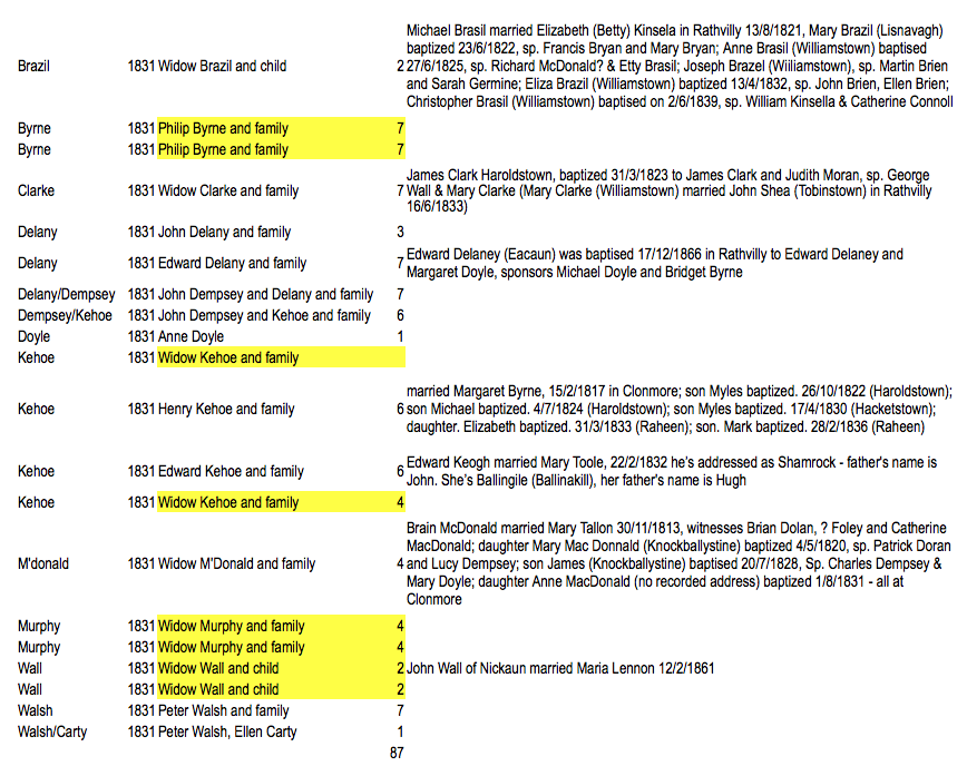
John Delany and family. 3;
Widow M’Donald, ditto, 4;
Widow Clarke, ditto, 7;
Edward Delany, ditto, 7;
Philip Byrne, ditto. 7;
Widow Murphy, ditto, 4;
Widow Wall and child, 2;
John Dempsey and Delany, ditto, 7;
Philip Byrne, ditto. 7;
Widow Murphy, ditto, 4;
Widow Wall and child, 2;
John Dempsey and Kehoe, ditto, 6;
Widow Kehoe, ditto,;
Peter Walsh,
Ellen Carty, 1;
Henry Kehoe and family, 6 ;
Edward Kehoe, ditto, 6;
Widow Kehoe, ditto, 4;
Peter Walsh, ditto, 7;
Widow Brazil and child, 2:
Anne Doyle, 1;
In all seventeen families, amounting to eighty individuals, were driven off these lands in 1831.
Since that period all but two of the ejected widows have died, under the united pressures of age and distress. To leave no room for cavil, it is right to observe that five of the above families were turned off by middleman, acting, however, as is asserted, under the orders of the head landlord.
In the year 1835 the lease of the remaining part of this townland expired by the death of Mr Luke Harney, when a repetition of the same scene took place by the ejectment of the following seventeen families:-
John Harney and family, 11;
Michael Harney, ditto, 8;
Thomas Harney, ditto, 9;
Widow Harney, ditto, 3;
Sylvester Donohoe, ditto, 5 :
Wm. Doyle, ditto, 7;
Richard Doyle, ditto, 3;
Widow Whelan, ditto, 6;
Thomas Trainer, ditto, 4;
Michael Byrne, ditto, 5;
Patrick Murphy, ditto, 7;
John Burke, ditto, 8;
John Doyle, ditto, 3;
Edward Doyle, ditto, 3:
John Quigley, ditto, 6;
Charles Watts, 1;
Morgan Murphy, ditto, 4.
Total, 93.”
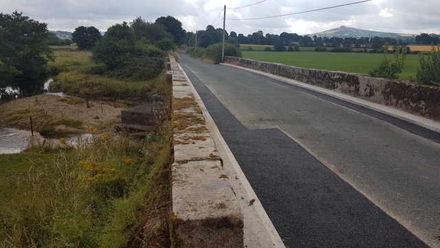
The next bridge up the Dereen from Acaun is Saulsford Bridge, known locally as ‘The Steps’, seen here with Eagle Hill in the background. James Grogan found William Saul laid to rest just beside the Hozier tomb in Hacketstown. In Griffith’s Survey, William Saul held a tenancy in Ballykillduff from Abraham Brewster, the barrister responsible for the Haroldstown Clearances. Mr Saul later moved to Ballykillane House closer to Hacketstown (beside Saulsford Bridge), where he again had a lease from Mr. Brewster. There is some graffiti on Saulsford Bridge written by Chris Gahan, Dan Tompkins and Paddy Blake who worked on the bridge between 1987 and 1994.
It thus appears that 173 individuals have been turned off these lands since they came into the possession of Mr Brewster. Several of them have been twice ejected – turned out of that part of the townland, the lease of which expired in 1831 … they took refuge among their neighbours on the other part, from which all have been ejected on the expiration of the second lease, in 1835. The whole of the land from which these Catholic families have been banished—the land of their birth—has been transferred to three Protestants of the names of Jones, Fenton, and Stewart, with the exception of about twenty-five acres which were given to Pierce Byrne, a Catholic. Of this man’s trimming politics you arc well aware. He has ever been the interested tool of the Tory party, and as such claims their favors, although a Catholic, equally with their Protestant neighbours.
Since the last expulsion the sufferings of the ejected have been great. Most of the poor creatures have remained nearly houseless to the present day—some sheltering themselves in temporary huts on the road side —some in the ruins of an old mill, where they have passed the winter in the deepest misery.
It is not for me to suggest the motives which may have actuated Mr. Brewster in turning so many fellow-Christians adrift —eheu quam multos! It may be said that in 1831 he wished to let his lands in large farms, but in 1835 this reason will not be available, as he evicted farmers at that time who held considerable tracts, and were well known to be industrious the popular candidates.
In my humble judgment, however, they were Catholics, and such as had not supported driven from the land of their fathers, whether the catastrophe is to brought about by the machinery of Malthusian consolidation, or that of Conservative vengeance.
Believe me to be, &c. &c.,
Denis Lawlor. P.P.’ [13]
Were their buildings unroofed after the eviction, to prevent the poor souls from resettling? I do not know who was looking after Lisnavagh at this time but surely they heard the wails of eviction. Tom Bunbury owned the land, but he was an absentee for much of this time. Everything I know about Kane Bunbury tells me he would have abhorred this action.
Daniel O’Connell maintained that Mr. Brewster was ‘the only gentleman of the Irish bar that I ever heard was guilty of this practice’ (ie: eviction). On 28 October 1841 O’Connell declared:
‘One of the greatest evils of Ireland was the extermination of Irish tenantry and it was a shame for a government… to appoint such a man as Abraham Brewster to a situation under the executive.’
He also denounced Lord “Humbug” Elliot for appointing Brewster, albeit acknowledging that Elliot had to comply with the appointment when several judges threatened to resign if he didn’t. Brewster, who became Solicitor General of Ireland in 1846, was to play a major role in the preparation of O’Connell‘s trial over the monster meeting planned for Clontarf in 1843.
 The Haroldstown Families
Armed with the above information about the evicted families, James Grogan set to work in August 2018 looking up the names on www.rootsireland.ie and Griffith’s (1851/1852) to try to find possible children of the above, working back to 1831/1835 as ‘one generation back.’
He identified many of the Haroldstown families by looking at the births and marriage records for the three parishes of Rathvilly, Clonmore and Hacketstown, which between them had jurisdiction over the general Haroldstown / Acaun / Ballykilldfuff / Williamstown areas. He has not yet looked at any death records. As James observes, some of the following does not align perfectly and he urges readers to be clear that his conclusions are ‘presumptive’. Nonetheless, it makes for an excellent addition to the tale.
James Grogan added: “I couldn’t find anything for Charles Watts but I wonder if it was supposed to have been Charles Oakes (b. 23/1/1831), son of Charles Oakes and Mary Byrne, sp. Charles & Mary Demspy, who was listed for Acaun – his mother and sponsors have surnames seen elsewhere on the list. I have highlighted some entries in yellow and wonder if they are duplications. There was a Catherine Harney of Haroldstown that married Thomas Kelly on 11 Nov 1835 in Clonmore parish, but I couldn’t find any certain Widow Harney candidates or the other Harney men mentioned. Unfortunately, Catherine’s father’s name was not recorded. There was a Patrick Harney that married Esther Butler of Aghold in the Clonmore parish in Feb 1838 but it doesn’t give either parents or where he lived. The Doyles, Dempseys, Byrnes and Kehoe/Keogh names are so prevalent over there it is not easy to home in on the ones mentioned.”
Latter Days of the Brewster Era
On 11 January 1858, the Dublin Daily Express observed:
‘Mr. Brewster, Q.C., visited his estate at Haroldstown, Co. Carlow, last week. The learned gentleman stopped with his relative, John Watson. Esq., Ballydarton, during which hunted with the Carlow and Island Hounds, and appeared very much to enjoy the sport.’
In 1841, Abraham Brewster was appointed Law Adviser to the Lord Lieutenant of Ireland (or a ‘secret adviser at Dublin Castle’, as O’Connell put it), prompting Daniel O’Connell to lambast him as the most ‘truculent enemy of the Catholics and of Catholicity’ and the most ‘avowed enemy of the rights of the Catholic people of Ireland at the bar.’ He was appointed to the Privy Council in 1853.
Brewster served as Solicitor-General and Attorney-General before being appointed Lord Chancellor of Ireland in March 1867, during Lord Derby third term as prime minister. He only retained the office until 17 December 1868, when Benjamin Disraeli’s government resigned, after which he retired from public life. He died at his residence, 26 Merrion Square South, Dublin, on 26 July 1874, and was buried at Tullow, County Carlow, on 30 July.
Brewster also rented land at Ballynultagh from the Fitzwilliam estate at Coolattin, along with the woods still known to older locals in 2024 as Brewster’s Wood. After his death in 1874, it is thought a new lease of this land was taken up by James Tallon of Stratnakelly. There were two houses in the Far Field, one in the top corner joining Clares and one in top corner joining the Quarry Field. There was another house in the top corner of the Fack Step joining the Quarry Field and Far Field. All three houses were occupied by the families of men who worked for Abraham Brewster. Following the Wyndham Act of 1903, the 7th Earl William Fitzwilliam agreed to sell all but 5,000 acres of the Coolattin Estate. Tenants were given to opportunity to purchase the lands which they leased. On 29 September 1908, Elizabeth Tallon, the widow of Laurence Tallon, bought the original house, farmyard and land at Stratnakelly, along with the two parcels in Ballynultagh. This was done on a 60 year mortgage which was completed in the 1960s.
By his marriage in 1819 with Mary Ann, daughter of Robert Gray of Upton House, County Carlow, Abraham Brewster had issue one son, Colonel William Bagenal Brewster, and one daughter, Elizabeth Mary, wife of Mr. Henry French, both of whom died in the lifetime of their father. As Mary Ann had died in 1862, he left the estate to his grandson when he died in 1874. This was then worth £127,000 or perhaps £16million in today’s terms.
A nephew, Edward Brewster, became a lawyer and politician in New South Wales. Abraham’s mother was Mary Bates, daughter of Thomas Bates.
R.A. French-Brewster, MP, of Haroldstown was on the Long Panel of the Grand Jury for the Carlow Spring Assizes in 1885. [14] He was still owner in 1888. [15] Indeed, it was still referred to as the Brewster estate as late as 1909 so I am unsure when they parted with it.
NB: Williamstown belonged to the Wolseley family of Mount Wolseley by 1872.
Latter Day Evictions
Amazingly, widows were still being evicted into the 20th century. The 1901 census recorded Margaret Murphy, a 40-year-old widow, living with her 14-year-old son Peter at Rathnagrew, near Hacktestown, in County Carlow. However, their landlord, Colonel Joshua Frederick Kemmis Betty, had just given notice that they were to be evicted.
Three years later, the Kildare Observer and Eastern Counties Advertiser of 20 February 1904 had this update when the Baltinglass Board of Guardians condemned her eviction “in the strongest possible manner,” despite the fact her son – perhaps Peter – was sending money home from America to settle her account.
(With thanks to Aoife McAdam).
Redistribution of Land, 1909
In 1909, the Wicklow People carried this upbeat letter from an evicted tenant named Peter Carroll to John O’Toole, ex-RDC, of Charlemont Street, Dublin:
Liscolman. Tullow, June 4, 1909.
Dear Mr. O’Toole—Your welcome letter to hand. Many thanks for your kind messege. The Brewster estate, Haroldstown, containing 212 acres, was the scene of distribution amongst 22 people. Of this number four were evicted tenants, including myself. The names are as follows, together with the number of acres allowed to each –
Murphy. Rathdangan, Hacketstown, about 32 statute acres;
Carroll. Liscolman, 27 ½ acres, together with part of yard and out-offices (which are in splendid repair): also magnificent hay barn, capable of holding 100 tons of hay;
Kealy. Hacketstown, about 30 acres;
Jeremiah Carthy, Carroree,. about 37 acres.
The Commissioners will build houses for all the tenants, except myself, and also grant each to the amount of £100 for stock. The remainder of the estate was allotted to a number of labourers and small holders in plots from 6 1/2 to 10 acres. A man named Mallin. who had been a caretaker for a number of years, also got a nice plot of land, about 35 acres, together with the house he had been living in and part of the out-offices. The rents will average almost 16s per acre statute.
Again thanking you for post favours, yours sincerely, Peter Carroll. [16]

Three graves of the Scott family of Ballysallagh and Hacketstown at Haroldstown Cemetery.
Acknowledgments
With thanks to JJ Woods for kick-starting these thoughts, James Grogan for spurring me on, and also to the late Dick Corrigan, Paddy & Clare Halligan, Edwin & Norah Burgess, Sue Clement, Ken Williams, Michael Brennan, Andy Goss, Cathy Goss, William Dick, William Bunbury, Ben Rathdonnell, Jamie Cahalane, Eimear Ni Bhraonain (KCLR), Alan O’Reilly (Carlow Weather), Neal Boyle, Coílín O’Driscoll, Michael Purcell, Kathryn Roundtree, Sue Clement, Anthony Heaney and others.
End-Notes
[1] Journal of the Association for the Preservation of the Memorials of the Dead” (Vol VI, Issue 1904 -05 – 1906, Carlow), p. 430.
[2] Thanks to Clare Halligan.
[3] Nicholas Carlisle, ‘A Topographical Dictionary of Ireland’ (W. Miller, 1810)
[4] Saunders’s News-Letter – Wednesday 02 April 1806
[5] From ‘Abstract of Conveyances from the Trustees of the Forfeited Estates and interests in Ireland, 1688 – County of Carlow’ With thanks to Cara
[6] For more, see Philip Savage by C. Ivar McGrath, Dictionary of Irish Biography
[7] Further details of all this, and the Ryan connection to Dunleckney, are in John Ryan’s History and Antiquities of the County of Carlow, p. 372-374. See also Thomas King, ‘John Ryan – Polemicist & Local Historian, Carloviana, Dec 1997, p. 71 to 73,
[8] I am not quite sure how this tallies with the Trotter or Ryan/ Pillsworth / Howard stories above. The Lisnavagh Archives includes a box of wills, leases, deeds, testamentary papers and account books (F/1/24) relating to the affairs of the Brewster family, who were involved with the Bunburys through friendship, executorship and as a result of a lease of Killerig, Co. Carlow, granted by Henry Bunbury to Thomas and John Brewster in 1748. The 2 wills present in the box are the probate of the will of Samuel Brewster of Ballywilliamroe, Co. Carlow, 1758, and the will of John Brewster of Brewster Lodge, Co. Carlow, 1785. There is an account book of John Brewster, 1758, an account book of Thomas Bunbury of Kill as guardian to ‘the Brewster minors’, 1758-1763, and an account book of ‘the executors of the late John Brewsters [sic] Esq.’, 1786-1802. Two deeds of 1803-1804 relate to a composition with the creditors of the late John Brewster. Abraham Brewster was also offering legal opinion on matters in the 1830s and 1840s.
Haroldstown Dolmen.
[9] Carlow Sentinel, June 1835; Cork Constitution, 12 December 1835
[10] This account from the Carlow Sentinel was published in the Lancaster Gazette, 5 December 1835.
[11] Dublin Monitor, 19 October 1841.
[12] The Rev. Lalor died on 10 February 1855, aged 64, and is buried in the Parish Church in Bagenalstown.
[13] Father Lawlor’s letter appears in ‘A Statement of persecutions on the part of certain Tory Landlords in the County of Carlow, referred to in a petition of N. A. Vigors, Esq., presented to the House of Commons, etc’ (J. Ridgway & Sons, 1836), p. 41. Thankfully the name Bunbury does not appear in that ‘statement of persecutions.’
[14] Carlow Sentinel – Saturday 14 March 1885.
[15] ‘Then came a visit to Haroldstown Gorse, which is on the property of Mr R. T. French-Brewster.’ From a hunting report in The Field – Saturday 18 February 1888, p. 25.
[16] Wicklow People – Saturday 19 June 1909.